
Mexico City—Ambitions and Challenges of Integrated Risk Management in a Fractured Urban Planning Context
 Soledad Garcia Ferrari
 Emma R. Morales
 Amelia A. Bain
- 1Edinburgh School of Architecture and Landscape Architecture, University of Edinburgh, Edinburgh, United Kingdom
- 2Departamento de Arte, Diseño y Arquitectura, Universidad Iberoamericana Puebla, Puebla, Mexico
- 3School of Geosciences, University of Edinburgh, Edinburgh, United Kingdom
Among the growing number of megacities, Mexico City stands out for its size and population, but also for its challenges with respect to environmental risk management, fractured governance and marked contrasts in urban conditions. In the last couple of decades, Mexico City has been praised for pioneering new management structures for planning and policy development, driving an approach rooted in a strong social commitment and sustainability agenda, with more integrated decision-making across government institutions. Among these instruments is the recent Law of Integrated Risk Management and Civil Protection of Mexico City, which boldly steps ahead of national legislation, moving from a reactive to a precautionary approach to disaster risk under the banner of stakeholder co-responsibility. However, this paper shows that Mexico City has also been the stage of innovative policies that have been hijacked by the powerful, tainted by corruption and reinterpreted to fit financial interests, or simply abandoned with the arrival of new administrations. The efficiency of these innovative strategies has therefore thus far been limited by discretionary practices and poor communication and socialisation. Our research over the past 5 years has explored risk management processes in Mexico and Mexico City through a transdisciplinary investigation of the vulnerability to climate change-related hydro-meteorological risks in low-income urban areas, and the capacities to manage risk at the community and institutional levels. Drawing on this research, this paper describes a range of accomplishments in urban and environmental policy innovation in Mexico City in recent years with relevance to risk management, and the opportunities for learning arising from the challenges, limitations, and failures. The paper argues that, despite extensive existing knowledge of the socio-technical elements of risk in the city, in particular in relation to hydro-meteorological and seismic risks, fragmented urban development policies and institutions have contributed to increasing the vulnerability of poor communities in high-risk areas of the city. The paper concludes that addressing the challenges of integrated risk management in this fractured urban planning context will require that the recently-created institutions are adaptive, to cope with evolving socio-economic contexts and physical hazards, build strong links with academia to harness social and technical knowledge, design long-term plans integrated across tiers of government to increase coordination, and generate strong and inclusive engagement of the city’s heterogeneous communities. These elements are crucial to allow Mexico City’s ambitions of integrated risk management to survive political cycles and avoid appropriation by short-term financial interests over real risk reduction.
Introduction
Established on an ancient lake-bed and framed by volcanoes showcasing the dynamic geological setting, Mexico City is one of the most enthralling megacities globally, but this environmental context has engrained an inherent need for long-term seismic and flooding risk reduction, in particular. Global warming has also compounded risks by shifting hydro-meteorological patterns. Climate change has been accompanied by a significant reduction in overall precipitation in central Mexico, contributing to water stress, while very heavy rainfall events have increased (Groisman et al., 2005), promoting flash flooding. Extreme precipitation and extreme dry-summer years are projected to continue increasing under climate change scenarios (Romero-Lankao et al., 2014), reinforcing these trends.
Academia in Mexico has played a strong role in pushing for a transformation in the National System of Civil Protection (Sistema Nacional de Protección Civil, or SINAPROC), away from a reactive system targeted at disaster management after the fact, towards a pro-active integrated risk management framework (Alcántara-Ayala et al., 2019). The proposed framework would aim to promote coordinated actions across government institutions at all levels, at the community level, and within the private sector, to reduce existing risks and avoid the construction of new risks, thus reducing disaster losses. Although this transformation has not yet taken place at the national level—to date, SINAPROC persists in its established form, celebrating 35 years of existence in May 2021 —, Mexico City recently adopted a progressive new Law of Integrated Risk Management and Civil Protection (PAOT, 2019), placing it at the forefront of disaster risk management in the country and on the global scene. The law aims to strengthen governance and promote a culture of risk reduction in the city under the banner of stakeholder co-responsibilities, including government, civil society, and the private sector. As such, it breaks with the reactive approach criticised at the national level, taking a precautionary and integrated approach to reducing risk in the city.
This new law and accompanying regulations have created an innovative framework, supported by new institutions, and in line with recommendations from international agreements such as the Sendai Framework for Disaster Risk Reduction (DRR) to “guide the multi-hazard management of disaster risk in development at all levels, as well as within and across all sectors” (UNISDR, 2015). The implementation of such integrated risk management approaches aims to deliver a substantial reduction of disaster risk and losses, through an explicit focus on people and their livelihoods, regular hazard monitoring, combined with stronger governance. In particular, integrated risk management promotes a deeper understanding and reduction of the underlying causes of risk and the achievement of tangible risk reduction on a local level, which are elements of DRR that have historically remained elusive (Pearson and Pelling, 2015). Globally, while the successful integration of science and policy has tended to deliver improvements in understanding hazards and implementing early warning systems, a lack of focus on understanding the societal drivers of risk has hampered achieving impact in vulnerability reduction (Pearson and Pelling, 2015). In this paper, within the context of the set of newly-created institutions tasked with designing plans for coordinated risk management across different tiers of government in Mexico City, we review some of the challenges and pitfalls associated with urban planning in the city, including illustrative examples of inter-institutional disarticulation and failure of environmental risk management planning which have contributed to increasing vulnerability in at-risk communities. These examples were identified through our research and professional practice within the fields of urban planning and risk management in the city.1 Our research included interviews with institutional actors responsible for risk and water management in the context of several research projects, as well as interviews and focus groups with communities in key neighbourhoods experiencing repeated flash-flooding. Through the examples described in this paper, we demonstrate that policies intended to improve urban conditions have instead resulted in increasing the population of socio-economically deprived people in areas exposed to frequent flash-flooding and high seismic hazard. On the basis of this transdisciplinary analysis, the paper also highlights the opportunities for real impact at the local level that Mexico City’s new legislation offers.
City Administration and Overall Context
Mexico City (Ciudad de México) — formerly the Federal District (Distrito Federal) of Mexico, and now frequently referred to by its acronym ‘CDMX’ (for Ciudad de México) — is the capital and most populous city of Mexico and one of the most important financial centres in the Americas (UN Habitat, 2014). Located in the Valley of Mexico at an altitude of 2,240 m above sea level (Figure 1), the Greater Metropolitan Area of Mexico City (Zona Metropolitana del Valle de México) is one of the ten largest metropolitan areas in the world, and is projected to remain in the top ten in 2030 (United Nations, 2018). Administratively, the greater metropolitan area includes municipalities from three different federal states (Ciudad de México, Hidalgo and Estado de México), with an estimated population of around 21 million in 2015 (SEDATU/CONAPO/INEGI, 2018).
FIGURE 1
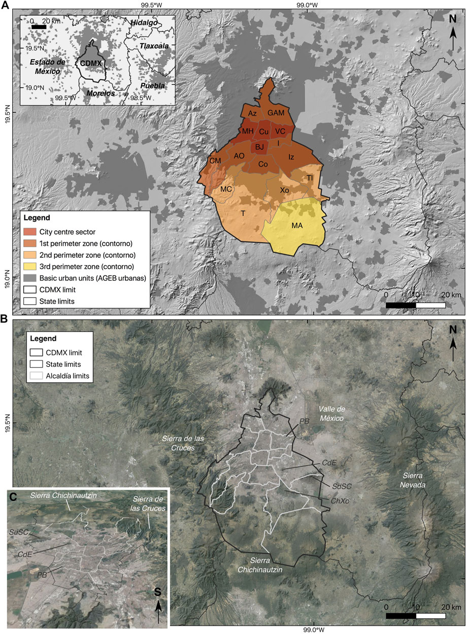
FIGURE 1. (A) Sectors and boroughs (alcaldías) in Mexico City, based on the General Urban Development Programme of the Federal District (GDF, 2003). The urbanised area of the Greater Metropolitan Area of Mexico City is shown in dark grey. Abbreviations for the boroughs of the city are defined in Table 1. (B) Satellite view of Mexico City within the Valley of Mexico basin (Valle de México), surrounded by three mountain ranges (Sierra de las Cruces, Sierra Chichinautzin, Sierra Nevada). ChXo represents the chinampas of Xochimilco, where crops are grown on the shallow lake bed of Lake Xochimilco, a remnant of the ancient lake system which occupied the valley in pre-colonial times. PB (Peñon de los Baños), CdE (Cerro de la Estrella) and SdSC (Sierra de Santa Catarina) represent small volcanoes that formed islands within Lake Texcoco; these mounts now represent high ground looming over residential areas of the city, from which heavy rains run off to form flash floods. (C) Three-dimensional view of Mexico City looking towards the south, showing the low altitude of the northern part of the city on the site of former Lake Texcoco compared to the more mountainous and rural south (shown with a vertical exaggeration of 1.5). The black line shows the city limit. Figures prepared using QGIS 3.16 software (QGIS.org, 2021), using the digital elevation model of INEGI (2012), open data from INEGI (2020), and Google Satellite imagery (Image Landsat/Copernicus, accessed December 2021).
Since its foundation in the 16th century, Mexico City has exemplified perpetual policy and administration changes linked to power and social control, but also in response to the complexity of running a city with enduring environmental and sanitation problems connected to increasing urbanisation (Glasco, 2010). The phenomenal expansion of the city is illustrated by the size of the original pre-Hispanic settlement, Tenochtitlán, which had an approximate surface area of 13 km2 shortly after its foundation on an island within Lake Texcoco in the early 14th century, in contrast to the 2,291 km2 covered by the modern city in 2010 (González-Arellano and Larralde-Corona, 2019). Whereas urban growth originally occurred around the chinampas—floating fields on the shallow lakebed—few remnants of this lacustrine environment have resisted against the urban sprawl (Figure 1).
The city has long been the seat of power in the region, since the Aztec empire, throughout the Viceroyalty of New Spain, and as the nation’s capital following Mexican independence in the 19th century. The history of Mexico City embodies the social conflicts, instability and administrative challenges of the independent nation. The city became a Federal District—an administrative division under the direct control of the federal government—in 1824, following intense congressional debates. From then, the city concentrated all “supreme” powers of the federal government, centralising political and economic power, with the city budget, government, and policies bound to the presidency (Nava-Vázquez, 2007). However, there have been important administrative changes and discussions around the city’s legal frameworks in recent years towards increasing autonomy, decentralisation and local representation. On 29 January 2016, as part of a broader political reform, the Federal District legally became Mexico City, endowing the capital city with a similar status to Mexico’s remaining 31 federal states. Yet, the implementation of the city’s new Constitution, the conformation of the city Congress, and the creation of necessary new administrative structures such as the Institute for Democratic and Prospective Planning (Instituto de Planeación Democrática y Prospectiva) have all been contested. For example, the implementation of the Institute suffered from lengthy delays (see Fragmented Urban Planning and Risk Management in Mexico City), and widespread political discord arose around the selection of its Head (Olson, 2020). The Institute now concentrates power and responsibility for planning in the city (Rueda, 2019), yet there is significant disagreement with the plans that it is currently attempting to implement (Cuenca, 2022; Ramírez, 2022; Sosa, 2022). These difficulties begin to illustrate that innovative policies, laws or plans that strive to improve urban conditions or management through new structures or approaches in the city can stagnate or fade without effective institutional and instrumental support.
Mexico City’s administrative arrangements contribute to further complexity. The city is divided into 16 boroughs, previously identified as delegaciones and now termed alcaldías following the political reform of 2016. With the transformation to alcaldías, the boroughs have supposedly gained greater autonomy and political diversity. In practice however, local authorities find it challenging to match innovative visions with old structures; it has also become more difficult for the city’s Head of Government to reach agreements involving more than one alcaldía, as these are governed by democratically elected mayors that often represent different political parties with different priorities and interests. In addition, the city is the core of the economic activity of the central region of the country, and the centre of the megalopolis that includes territories from seven federal states, with approximately 39.3 million residents (Aguilar and López, 2018). The megalopolis is a social, economic and political powerhouse in the region, almost eight times larger than the Puebla-Tlaxcala metropolitan zone, the second in the central region of the country. If reaching agreements between alcaldías is a daunting task, it is even more challenging to address shared problems in the megalopolis because of the lack of a comprehensive metropolitan policy and institutional support.
Aguilar and Lopez (2018) describe the internal urban dynamics of Mexico City according to three main characteristics: 1) increasing sprawl, along with metropolitan and peripheral urbanisation; 2) social inequality; and, 3) a lack of regional development and coordination. These drivers shed light on some of the reasons why innovative urban and environmental policies have often fallen short in this megacity. For example, spatial planning and policy implementation require intergovernmental strategies because a large proportion of the urban sprawl and peripheral urbanisation lies beyond Mexico City’s administrative boundaries (see Figure 1A). The lack of regional coordination contributes to dispersed and fragmented urban structures and an unequal distribution of infrastructure, public services and public facilities. As a result, Mexico City is characterised by significant social polarisation, labour inequality, and social exclusion: around 2.5 million people, 28.7% of the residents of Mexico City, lived in poverty in 2010 (CONEVAL, 2012); by 2018, the percentage of people living in poverty had increased to 32.3%, representing around 2.9 million people (CONEVAL, 2018). The pressing social needs in this highly unequal context compel local authorities to respond to everyday urgencies instead of longer-term priorities, such as risk reduction (Quiroz Benítez, 2013; Eakin et al., 2020).
Importantly, owing to the complex institutional division and social inequalities within the city, Mexico City faces different urban, social and economic challenges depending on the geographical area. The 16 boroughs are grouped in four different sectors according to the 2003 General Urban Development Programme (Programa General de Desarrollo Urbano del Distrito Federal) (GDF, 2003). The highest population densities and the location of the most important Mexico City landmarks, business and commercial areas are located in the “City Centre” sector (Figure 1; Table 1), which includes the boroughs Benito Juárez, Cuauhtémoc, Miguel Hidalgo, and Venustiano Carranza. The population of these areas has decreased in recent decades as a result of various factors, such as earthquakes, gentrification, changes in family structures, and voluntary displacement to the peripheries (Delgado, 1990; Aguilar et al., 2003). However, in the past decade, most real estate development has been concentrated in these four boroughs. In contrast, the 1st contorno (perimeter zone, Figure 1 and Table 1) includes seven boroughs that face the most critical challenges concerning water supply, employment, and security, and concentrate some of the most vulnerable populations. Finally, the main challenges facing residents in the 2nd and 3rd contornos, which comprise a lower percentage of urban areas (Figure 1; Table 1) relate to maintaining their natural resources and traditional rural and semi-rural structures in the face of urban sprawl.
TABLE 1
TABLE 1. Sectors and boroughs (alcaldías) in Mexico City (GDF, 2003), with the corresponding population, population density, percentage of population in poverty and extreme poverty (estimated using the basic unsatisfied needs method), and the normalised marginalisation index based on data from the 2020 Population and Housing Census (data available from SEDECO, 2021; Gobierno de la Ciudad de México, 2021; CONAPO, 2021a). The population subtotal(†) is given for the boroughs belonging to each sector, whereas the average for each sector(‡) is given for the population density, percentage of population living in poverty, and marginalisation index. Note that the normalised marginalisation index (CONAPO, 2021a) is based on nine socio-economic indicators relating to education, housing, population distribution and monetary income. The normalised index lies between 0 and 1, with higher values representing lower levels of marginalisation (overall the boroughs of CDMX have low levels of marginalisation in the national context, but small differences in the index reveal socio-economic disparities across the city, see Figure 3).
The following section gives an overview of the principal environmental challenges facing Mexico City. Fragmented Urban Planning and Risk Management in Mexico City then provides a synthesis of recent urban developments that illustrate the fragmented nature of urban planning and risk management in the city, and Construction of Risk Through Recent Socio-Territorial Changes in Mexico City provides a summary of recent socio-territorial changes which demonstrate the increasing vulnerability of low-income communities exposed to environmental risks. Finally, Challenges and Opportunities for Integrated Risk Management in Mexico City reviews current spatial and environmental policies in Mexico City, exploring the opportunities and challenges related with its ambition to create a culture of integrated risk management in the city.
Environmental Characteristics and Challenges
Mexico City is located in the Valley of Mexico (Figure 1B), a basin forming a closed hydrological unit (Arce et al., 2019), which led in prehistoric times to the seasonal development of an extensive system of lakes due to runoff from the surrounding mountain ranges (SGIRPC, 2020). The original city of Tenochtitlán was constructed by the Aztec (Mexica) people on an island located within former Lake Texcoco, located in the modern borough of Cuauhtémoc (Figure 1A). These pre-Hispanic settlers were masters in the management of water in the city, via the construction of a sophisticated system of dams and aqueducts (SACMEX, 2012). As the flood-control infrastructure built by the Mexicas fell into disrepair following the Spanish Conquista, a series of destructive floods motivated the drainage of the lake (SACMEX, 2012). Over the following four centuries, the city expanded over the sediments representing the former lake bed (Figure 2A). The location of part of the modern city on low-lying ground (Figure 2B) underlain by these prehistoric sediments is an important factor in the physical vulnerability of people living in the north-eastern part of the city: the unconsolidated lake sediments amplify seismic waves during earthquakes (Ordaz and Singh, 1992) and create resonance effects (Flores et al., 1987), exacerbating shaking and damage (Figure 2C); the low-lying topography also exposes the population living in the north-eastern part of the city to flooding hazards (e.g., Novelo-Casanova et al., 2022; Figure 2D). In particular, isolated volcanic mounts (Figure 2A, 3) that formed islands within former Lake Texcoco now represent high ground within the modern city from which runoff during high-intensity rainfall events in the rainy season causes recurrent flash flooding in the lower-lying residential areas (García-Soriano et al., 2020). The unconsolidated nature of the sedimentary deposits underlying these residential areas, combined with tectonic movements and intensive groundwater extraction, also generate significant issues related to land subsidence (Figueroa-Miranda et al., 2018) and structural integrity of buildings and drainage infrastructure (SGIRPC, 2020), which compounds seismic and hydro-meteorological risks.
FIGURE 2
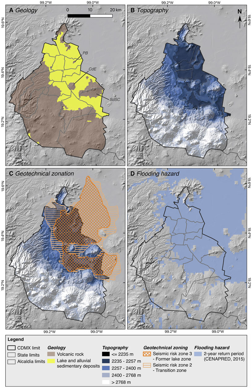
FIGURE 2. Environmental characteristics, seismic risk and flooding risk in Mexico City. (A) The southern and western parts of the city are underlain by hard volcanic rocks, whereas the northern and north-eastern parts of the city are built over unconsolidated sedimentary deposits representing the lake-bed of former Lake Texcoco. The small volcanoes that pierced the surface of the lake stand out within the sedimentary deposits: SdSC (Sierra de Santa Catarina), CdE (Cerro de la Estrella) and PB (Peñon de los Baños). (B) The topography of the city is consistent with the geological contrast shown in panel A, with low-lying areas in the north and north-east of the city corresponding to the former lake bed and higher topography in the south and south-west corresponding to the areas underlain by volcanic rock. (C) The geotechnical zonation of the city is based on the underlying geology, and defines three seismic risk zones: Zone 3—the highest hazard zone corresponding to the low-lying areas of the city underlain by the unconsolidated sedimentary deposits of the former lake; Zone 2—an intermediate hazard zone corresponding to a transition zone between the unconsolidated deposits and volcanic rocks; and Zone 1—the lowest hazard zone corresponding to the higher ground underlain by volcanic rocks (all remaining areas of the city outside Zones 2 and 3). (D) The flooding hazard in the city also closely corresponds with the low-lying areas of the former lake-bed. Figures prepared using QGIS 3.16 software (QGIS.org, 2021), using the digital elevation model of INEGI (2012), open data from INEGI (2020), the Risk Atlas of Mexico City (SGIRPC, 2021), and the National Flooding Risk Atlas (CENAPRED, 2015). Panels B and C use the Oslo colour ramp from Scientific colour maps version 7.0.1 (Crameri, 2018).
FIGURE 3
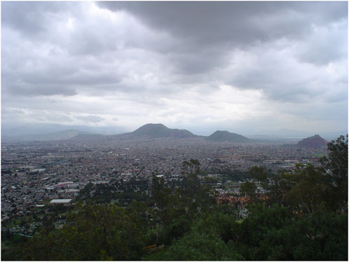
FIGURE 3. View of the southern part of Iztapalapa from Cerro de la Estrella (CdE), looking towards the volcanic mounts of Sierra de Santa Catarina (SdSC), see Figures 1B, 2A for map locations. Low-lying residential areas in Iztapalapa frequently experience flash flooding during heavy rainfall in the rainy season due to run-off from SdSC and CdE. Image attribution: Crater_sp on Flicker (available at: https://www.flickr.com/photos/crater_ae/387957644/sizes/l/in/photostream/; CC BY-SA 2.0).
Due to the geological setting of Mexico City (Figure 2A), distant large earthquakes have the potential to cause significant damage in the city (Novelo-Casanova et al., 2022). Recent damaging earthquakes have occurred in 1957, 1985 and 2017 (Congreso de la Ciudad de Mexico, n.d. a). The most widespread destruction was caused by the strong (M 8.0) earthquake of 19 September 1985, with an epicentre in the coastal region of the state of Michoacán, approximately 370 km from the capital. This event caused an estimated 6,000–8,000 fatalities (depending on the source) and destroyed or damaged over 100,000 homes in Mexico City (SEDEMA, 2016). A strong (M 7.5) aftershock occurred 2 days later, compounding the impact. These events injured an estimated 30,000 people, rendered 250,000 homeless, damaged 900,000 homes, and made 150,000 people unemployed (SEDEMA, 2016). More recently, on 19 September 2017, a strong earthquake (M 7.1), with its epicentre in the state of Puebla, caused 228 fatalities and damaged around 6,000 buildings (Congreso de la Ciudad de México, n.d. a). Most of the damage from these earthquakes was concentrated in the urban areas built on top of the unconsolidated sediments representing the former lake-bed, illustrating the high seismic risk in the north and north-east of the city (Figure 2C).
Earthquakes now tend to be perceived as the highest public risk (Santos-Reyes et al., 2014), however the low impact of an M 7.6 earthquake (with an epicentre in Michoacán as in 1985), which occurred on 19 September 2022 (Gobierno de la Ciudad de México, 2022) may suggest some gains in terms of vulnerability reduction, although this requires further study. The infrequent, though still potentially high impact of large earthquakes stands in contrast to the chronic risk associated with much more frequent exposure to hydro-meteorological hazards, in particular high-intensity rainfall events, flash flooding, and droughts. Water management represents an enduring challenge for Mexico City, not only from a risk management perspective but also from a social equity perspective, due to recurrent flash flooding in parallel with increasing water scarcity. The geographical location of the city renders it vulnerable to the impacts of climate change, which is exacerbating the hydro-meteorological hazards (Groisman et al., 2005). Crucially, these risks are magnified by human actions, such as unsustainable development that is not risk-informed. For example, the overexploitation of aquifers below the city has contributed to land subsidence and the related risks described above (Figueroa-Miranda et al., 2018). Furthermore, the city’s expansive growth has altered the hydrological system in the valley to the extent that many bodies of water have completely disappeared (Tortajada and Castelán, 2003; Legorreta Gutiérrez, 2006), a situation worsened by the state-led paving over of around 45 rivers in the 20th century (Departamento del Distrito Federal, 1964, in Sanchez Inzunza, 2016). One of the most important environmental sites for conservation is the remaining Lacustrine System of Xochimilco and San Gregorio Atlapulco (Figure 1B), recognised in the Ramsar Convention on Wetlands (INEGI, 2017). Water, therefore, has a dual character in Mexico City: it played a fundamental role in the foundation of the city, but is also associated with chronic hazards and risk for vulnerable modern communities (Tellman et al., 2018).
The Mexica settlers chose their island location “for strategic reasons,” but the city has been struggling with flooding and other water-related problems since its inception; Connolly (2003, p. 4) highlights that “this paradox of too much and too little water has characterised Mexico City’s growth throughout history and has been a major factor in urban segregation.” For example, the locations of wealthier neighbourhoods mark the areas on higher ground in the north-western sector of the city that are comparatively safer from flooding (e.g., the zone from 2,257 to 2,400 m which runs broadly NW-SE in Figure 2B, see also Figure 4B). These areas also have better access to water supplies (Gilbert et al., 2016), demonstrating the importance of socio-economic factors in water security and hydro-meteorological risk in the city.
FIGURE 4
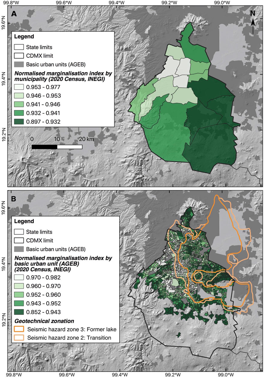
FIGURE 4. Socio-economic disparities and risk in Mexico City. (A) The normalised marginalisation index (which lies between 0 and 1, with higher values representing lower levels of marginalisation–see Table 1) for the boroughs of Mexico City indicates broadly higher levels of marginalisation in the outer perimeter zones compared to the centre, as well as in the east of the city compared to the west. (B) The normalised marginalisation index at the scale of the basic urban units of the city reveals a more detailed picture of socio-economic disparities, with a band of lower marginalisation running broadly NW-SE on higher terrain belonging to the transition zone between the former lake-bed and the volcanic rocks making up the higher ground. The north-eastern sector of the city with higher levels of marginalisation is therefore exposed to the greatest seismic hazard (Zone 3) as well as a chronic risk of flooding (Figure 2D). Figures prepared using QGIS 3.16 software (QGIS.org, 2021), using the digital elevation model of INEGI (2012), open data from INEGI (2020), CONAPO (2021a, 2021b), and the Risk Atlas of Mexico City (SGIRPC, 2021).
In the period from the 16th to 19th centuries, large-scale drains, pits, and tunnels were built for flood protection, draining the lakes and carrying excess rainwater out of the Valley of Mexico basin (CDMX Resilience Office, 2016, p. 25). Current challenges are not only linked to urban and population growth, coupled with more frequent high-intensity hydro-meteorological events driven by climate change, but also to political and regulatory decisions that have increased the city’s vulnerability (Tellman et al., 2018). For example, policies in the 1960s led to most rivers being covered to increase the available surface for building roads and car-oriented infrastructure, which severely altered the hydrological system (Departamento del Distrito Federal, 1964, in Sanchez Inzunza, 2016). Although there have been significant investments in water infrastructure, such as the construction of the “Lerma System” (completed in 1952) and the “Cutzamala System” (completed in 1992), which transport 30% of the city’s water from other regions (SACMEX, 2012; Tellman et al., 2018), the Valley of Mexico is facing an unprecedented climate crisis with a high risk of creating social conflict (Martinez et al., 2015). The city’s growing population is increasing water demand, and the current infrastructure is insufficient and outdated, despite repeated attempts to address this issue (Tellman et al., 2018). There is also limited action at the household and neighbourhood levels to deal with these issues, making it more difficult to implement long-term actions and plans.
The territorial challenges are not limited to geological and hydro-meteorological factors; urban sprawl is also affecting residents’ quality of life in the city and the future of ecosystems (Merlín-Uribe et al., 2013). In recent decades, Mexico City has faced critical challenges such as air pollution, water shortages, loss of biodiversity, health issues, heavy traffic, and other crises that demonstrate the important links between urban policies, everyday practices and environmental challenges. There is broad agreement between academia, public officials, and social organisations that the issues of flash flooding and drought require immediate actions and important changes in everyday practices. However, actions and results have been limited because politicians and the majority of the population have been more concerned about immediate and more visible actions on issues such as security, paving, streetlights, water provision and waste management. This short-term vision has affected the opportunities for impactful actions, even with the support of global networks and funding.
The above reflects the trend in the Global South, and particularly in Latin America, where approaches to reducing vulnerability through risk management and adaptation strategies are typically based around top-down decision making, coupled with a lack of institutional capacities to address the accumulation of risks within low-income and informal settlements (e.g., Satterthwaite et al., 2020; Smith et al., 2020). The implementation of such “traditional” forms of governance has yielded limited success in low-income and informal communities in creating sustainable solutions (Garcia Ferrari et al., 2021). Appropriate mitigation and adaptation measures, including necessary infrastructure solutions, are difficult to implement due to resource implications, but also due to complex socioeconomic, political and institutional processes, particularly around low-income and informal settlements (Smith et al., 2020). In parallel, theoretical discourses in the field of risk management have gradually evolved from a recognition of the importance of community-based and local-level risk management (e.g., Maskrey, 1984; Maskrey, 2011; Lavell, 2006), to the current focus on interlinkages between building resilience and sustainable development (e.g., Wilches-Chaux, 1993), and the importance of integrated risk management and citizen participation (e.g., Sendai Framework (UNISDR, 2015) and Sustainable Development Goals (UN General Assembly, 2015)). As will be further described in Challenges and Opportunities for Integrated Risk Management in Mexico City, these approaches have begun to permeate into governance internationally and in Mexico City, placing emphasis on the importance of stakeholder co-responsibility and citizen participation in risk management.
Fragmented Urban Planning and Risk Management in Mexico City
Urban development in Mexico City has been driven by two separate dynamics: while urban growth has been defined by social, economic and political circumstances, urban planning has focussed solely on the mitigation and adaptation to the effects of urban growth. As a result, there has been a lack of coordinated policies and actions focussed on risk management, while some innovative policies have contributed to increasing urban segregation and vulnerability due to co-option by strong financial interests, as described in this section.
Following Mexico’s independence from Spain, Mexico City grew significantly in size, population and economic weight (Connolly, 2003). In 1910, there was a wave of migration to the city as people fled the battles of the Mexican Revolution—between 1900 and 1930, the population tripled from 344,000 inhabitants to 1,029,000. Between 1930 and 1950, the greatest population growth occurred outside the City Centre sector, in the areas of Coyoacán, Azcapotlzalco, Tacubaya, La Villa and San Ángel. Likewise, during this period commerce and services were decentralised, and industrialisation contributed to expansion to the north; “the city expanded from around 23 km2 in 1900 to 683 km2 in 1970, to 1,295 km2 in 1990” (Connolly, 2003, p. 2). The metropolisation of Mexico City resulted from the settlement of industries in peripheral municipalities—mainly in the State of Mexico –, migration from rural areas to urban areas, and the creation of informal settlements.
The city was founded following Spanish Ordinances, which clearly defined how new settlements should be built. However, Mexico City did not have a clear urban planning law until the Federal District Planning Law (Ley de Planificación del Distrito Federal) of 1953. Most of the planning decisions were based on political, economic, industrial and infrastructure goals. Urban design and housing policies were therefore connected to specific neighbourhoods or particular state or private-led developments, such as Lomas de Chapultepec and Chapultepec Condesa in the early 1920s, or the first social multi-family residential estate Miguel Alemán in 1949.
The devastating earthquakes of 1985 then brought about significant changes in the shape and administrative configuration of the city. For example, the badly damaged central area, which formerly comprised one administrative unit, was split into four boroughs (Cuauhtémoc, Venustiano Carranza, Miguel Hidalgo and Benito Juárez). The need to rebuild following the earthquakes, along with incipient National Spatial and Strategic Planning policies, contributed in 1987 to the publication of the first General Programme for Urban Development of the Federal District, demonstrating the significance of the 1985 earthquakes in shaping the trajectory of urban planning.
However, the complexity of urban development, risk management and environmental protection, combined with intense pressure from the real estate industry, has made it challenging for local authorities to update these planning instruments in recent years; some have not been updated since the early 1990s. For example, a proposal to update Mexico City’s General Urban Programme has been on hold since 2016 due to failing to pass in the city’s Congress for political reasons (a new proposal is in the consultation phase at the time of writing). The intractable challenge of updating urban development programmes has promoted creative approaches, and the introduction of innovative planning and financing instruments that have contributed to the provision of housing, urban regeneration, and investment in water and green infrastructure. However, as these alternative instruments offer opportunities outside the official plans, they have been co-opted by real estate developers and political interests, with long-term negative effects on street life, entire neighbourhoods, infrastructure and services within the city. These planning instruments have therefore become tools for real estate speculation and veiled social segregation, rather than comprehensive plans to address social, environmental and urban challenges. As a result, the positive outcomes are often overshadowed by corruption and special interests above social benefits, and the planning instruments (examples of which include “Action polygons”—Polígonos de actuación, “Master plans”—Planes maestros, “Cooperative action systems”—Sistemas de actuación por cooperación, and “Potentiality transfer systems”—Sistemas de transferencia de potencialidad) have become ‘demonised’ by the media and neighbourhood committees. The predatory practices of urban developers in the past decade have rendered those instruments synonymous with corruption, social exclusion, habitat destruction, and increased vulnerability, damaging future planning initiatives.
Furthermore, a lack of transparency in public and private investment has contributed to distrust in financial instruments for planning. Some initiatives created immediate tangible improvements, for example the Historical Centre Trust (Fideicomiso del Centro Histórico), which was created as a private trust in 1990 to promote the renovation, protection and conservation of the city centre, and was converted into a public trust in 2002. However, more recent experiences, such as the private trust of the Granadas “cooperative action system,” which was created in 2015 and aimed to upgrade and consolidate 12 neighbourhoods within the Miguel Hidalgo delegación (Ciudad de México, 2015), have involved a lack of transparency around how financial resources were used (Leipziger, 2021). While real estate development in the Granadas system has “exploded,” lower-income residents have been displaced and inadequate water infrastructure has led to flooding issues (Leipziger, 2021). Such experiences have generated strong sentiments against private-public partnerships in planning in the city, and will undoubtedly affect future ventures aimed at addressing environmental challenges.
The political reform of Mexico City has brought new challenges because all legislation must be approved by the local government councils (cabildos) and the city’s new Congress. The new Planning Law of Mexico City, published in December 2019, defines the modern vision of urban development in the city and the conditions for creating the city’s new Democratic and Prospective Planning Institute. However, the selection of the head of this institute brought tensions between professional guilds, academic sectors and government officials, as many interests are at stake. Yet, the biggest challenge will be recovering citizen trust after a decade of aggressive real estate development. Indeed, the need for stronger institutions capable of addressing planning strategies from an autonomous position and with a long-term vision, such as the Planning Institute, was prompted by the power of real estate developers in the city. The creation of the institute was disrupted by events such as the 2017 earthquake, the change of national and city governments in 2018, and the COVID-19 pandemic. This lengthy delay in the implementation of the institute highlights a concerning gap between legislation and implementation, as well as a susceptibility to political cycles.
The federal government continues to play the role of a “central planning actor and holds the greatest share of planning competences in a highly legalistic structure” (Galland, 2018). However, Mexico City has struggled to implement macro-planning strategies, which is why small initiatives rooted in grassroots movements or local neighbourhood-level initiatives have sometimes had more effective results—particularly from an environmental risk reduction perspective. To tackle the complex problems highlighted above in this megacity, legislation addressing everyday issues but also engaging with a long-term perspective is needed. In particular, neighbourhood-level policy around environmental risks, e.g., earthquakes, flooding, water shortages, subsidence, air pollution, and adaptation to climate change-related risks, is needed. Systemic issues such as inequality, social fragmentation and basic public services provision in a fragmented, low-density expansive territory must also be addressed from the macro-level. However, there are currently limited planning tools, strategies, and involvement of local citizens to translate policies and laws into actions (Montejano-Castillo et al., 2022; Moreno-Villanueva et al., 2022).
Construction of Risk Through Recent Socio-Territorial Changes in Mexico City
Given the heterogeneous and unequal impacts of risk in different geographic and demographic contexts, it is critical to understand risk accumulation patterns linked to degrees of hazard exposure and social vulnerability (Maskrey, 2011). In Mexico City, economic development, which intensified with the industrialisation process that began in the 1940s, has played an important role in the current configuration of the city. By the 1970s, urban expansion had reached small rural towns, which faced a “lack of services, amenities, and the absence of land and property titles” (Gilbert et al., 2016, p. 17). In addition, a series of defining internal and external drivers have reshaped the socio-spatial fabric of the city since the 1980s, including: 1) the destructive earthquakes of 1985, and the economic crises prompted by the voluntary and involuntary displacement of residents to newer housing developments; 2) environmental crises and the air pollution emergency, which initiated a process of decentralisation of industrial activities, creating new demand for housing and services in the metropolitan area; 3) state-led social housing production in the outskirts; and 4) migration from rural areas. Extreme poverty and wealth now co-exist in Mexico City, characterised by “ingrained socio-spatial inequalities and […] imbalances between a large impoverished population and a growing number of multimillionaires” (Gilbert et al., 2016, p. 7). Vulnerability in Mexico City must therefore be considered within the context of a pattern of socio-spatial differentiation, where “upper and middle classes have settled with positive externalities such as freshwater, higher elevations safe from floods, woodlands, and access to roads and services,” and “low income households and rural migrants have […] established in irregular settlements in the eastern part of the Valley and in the hills of the Sierra de Guadalupe in the north” (idem).
The number and proportion of poor residents in the metropolitan area have increased over the last few decades due to urban growth and physical expansion. This has been accompanied by a growing demand for public goods and services, as well as pressure on the environment and natural resources, such as water (Graizbord and González-Granillo, 2019, p. 183). Although the population growth rate in the 2000s has been lower than in the 1960s and 1970s, urban sprawl continues to drive a high demand for water, transport, waste management, housing and public services and facilities.
In this context, local authorities have struggled to manage the provision of land, services and infrastructure. The first elected official to run Mexico City came in 1997, bringing an opportunity to introduce policy changes in housing, transport and urban development. For example, several urban renewal policies have been implemented since the 2000s aiming to improve living conditions in the city’s central area by taking advantage of the existing infrastructure and increasing population density. These policies were also intended to reduce the cost of extending municipal services to new settlements growing on the city’s edges (Adler, 2015). These policies against peri-urban development encouraged redensification in the four central boroughs (Miguel Hidalgo, Cuauhtémoc, Venustiano Carranza and Benito Juárez) in which the population had been decreasing since the 1980s. The city also launched an urban renewal programme in the historical centre, a UNESCO World Heritage site, led by the newly created Authority of the Historical Centre (Autoridad del Centro Histórico) with the support of the private sector. However, one of the most controversial policies aimed at re-densifying the central areas, named ‘Bando Dos’, triggered a series of unintended consequences, displacing lower-income populations to remote areas (Gilbert et al., 2016). Together, these policies enabled a real estate boom that contributed to an increase in land value, private investment, new commercial and office buildings, and an improvement in the urban image—however, thousands of families were displaced to areas of the city with greater exposure to hazards as a result of gentrification. These policies have unintentionally contributed to increasing the vulnerability of low-income families and exacerbating socio-economic disparities in the city. This example illustrates the constant evaluation, monitoring and adaptive governance required to effectively implement innovative urban policies which address the social construction of risk, with an approach allowing for restructuring or cancelling initiatives based on the observed impacts.
Furthermore, the redensification and urban renewal policies have not been as successful as expected. For example, 595,960 residents lived in Cuauhtémoc in 1990, and although the population growth evolved from -1.94% to 0.40%, the borough only reached 531,831 residents in 2010 (INEGI, 1990; INEGI, 2010) and 545,884 in 2020 (SEDECO, 2021). The same phenomenon was observed in the other four boroughs of the historical centre. Conversely, the population has increased in perimeter zone boroughs with a greater need for public services and infrastructure, as well as a greater exposure to risks (see Figures 1, 2). For example, the population of Iztapalapa, a large borough with the highest population in the city and frequent exposure to flooding (Figure 3), has increased from 1,490,499 residents in 1990 (INEGI, 1990) to 1,835,486 in 2020 (SEDECO, 2021), and has a population density comparable to the densest boroughs of the city centre sector (Table 1).
There is a clear overlap between the safer areas of the city from a seismic and flooding risk perspective and the concentration of wealth. Conversely, areas like Iztapalapa, Tláhuac and Xochimilco concentrate the highest population, with a high percentage of residents living in poverty (Table 1)—almost a million people in these areas do not have sufficient income to cover their most basic needs (Oxfam Mexico, 2020, p. 13)—and exposure to some of the highest hydro-meteorological risks. There are also issues around access to basic services in Iztapalapa, such as drinking water, which compounds the sanitation and governance problems. In this area, punctual actions have been taken to enhance community well-being and reduce risk, such as the creation of a public park (Parque Cuitláhuac) aimed at hydro-ecological regeneration on the site of a former landfill, and the installation of water pumping systems to mitigate against flooding. However these isolated actions have had limited impact in curbing recurrent flash-flooding, which damages housing and negatively impact health in the population following waste-water intrusion in homes. The area’s widespread subsidence problems also remain unaddressed.
Mexico City is therefore often described as a “fragmented city,” not only because of the profound social inequalities (e.g., Delgado, 1990) but also because of the territorial differences in quality and prices of services (e.g., water services, Legorreta Gutiérrez, 2006) as well as exposure to seismic and hydro-meteorological risks. As illustrated in Figures 2, 4, the exposure to seismic and hydro-meteorological hazards and social vulnerability is concentrated on the east side of the city, with an invisible border between the two sides representing the historical boundary between former Lake Texcoco and the island of Tenochtitlan. Mexico city is also a fragmented city from an administrative and policy perspective. The size and administrative complexity of the city makes it challenging to implement urban and risk reduction policies that are designed at a broad city-level, as this requires institutional commitment and deep understanding of the specific conditions (social, political, economic and environmental) in each separate urban and rural unit of the city. Environmental and risk mitigation and adaptation efforts are therefore usually concentrated in particular sections or sites, consisting of emblematic projects lacking a holistic environmental perspective.
Indeed, Mexico City has failed in several attempts to coordinate integrated policy and metropolitan governance that will embrace the city as a whole (Ward and Robles, 2012). The complexity of the territorial and administrative structures make it almost impossible to accomplish (Aguilar and López, 2018). More effective policy implementation through coordination between boroughs, as well as with the city government and the governments of adjacent states in the Greater Metropolitan Area of Mexico City, is required. However, different levels and tiers of governments (alcaldías, municipalities and state governments) are “unwilling to adopt a regional focus to benefit the city-region as they fear losing decision-making power in their own territory” (Aguilar & López, 2018). This is connected to short-term political commitment because state governors cannot be reelected, however there is hope at the municipal level, where re-election is now permitted. More generally, economic gain is consistently held above the public interest. There have been several attempts to address social inequalities; however, some of these efforts have been co-opted by economic interests. For example, General Spatial Planning Rule no. 26 (Norma de Ordenación General no. 26, known as “Norma 26”) intended to promote social housing production by offering developers the opportunity to omit certain planning regulations in order to deliver affordable housing. In practice, this scheme was used primarily for profit, with developers promoting small studios and appartments at high prices. The instrument had to be abolished in 2010, and no substitute has yet been implemented. Furthermore, civil society groups were excluded from the process of reforming the planning rule, despite existing legislation on citizen participation in Mexico City (Adler, 2015).
Challenges and Opportunities for Integrated Risk Management in Mexico City
As demonstrated in the previous sections, the hydro-meteorological and seismic hazards in Mexico City, coupled with extreme inequality, concentrate vulnerability in the poorer, more populous areas of the 1st Contorno (perimeter zone), such as Iztapalapa. However, at the city level, there is currently an apparent disconnection between environmental discourses and planning, and tangible actions and projects. One clear example is the response to repeated flooding disasters in Iztapalapa, where the resilience strategy presented to residents has been a recognition that their houses will continue to subside, suffer damaging flash floods and face omnipresent risk from emerging sinkholes and future earthquakes. The main response strategy to these risks has been disaster relief funding, which indicates that, thus far, structural problems continue to hinder the implementation of policies and programmes that aim to reduce risk.
Mexico City has some of the most comprehensive urban and environmental plans in Mexico. However, the ambitious long-term and large-scale vision of environmental plans negatively affect their implementation. For example, the most important national planning legislation is the General Law of Human Settlements, Land Use Planning and Urban Development (Ley General de Asentamientos Humanos, Ordenamiento Territorial y Desarrollo Urbano), based on principles such as the right to the city, equity and inclusion, urban property rights, democratic participation and transparency, productivity and efficiency, protection and provision of public spaces, resilience, urban security and risks, environmental sustainability, and universal accessibility and mobility (Cámara de Diputados, 2016). Despite these very ambitious principles, in practice it has proven difficult to convert these aims into policy and projects. As a result, this law has created unfinished business at every government level.
The National Land Management Strategy (Estrategia Nacional de Ordenamiento Territorial; SEDATU, 2021a) and the National Programme for Land Use Planning and Urban Development (Programa Nacional de Ordenamiento Territorial y Desarrollo Urbano; SEDATU, 2021b) published in 2021 are two highly valuable planning instruments from a risk management perspective, as they understand the territory as an urban-rural system that transcends the geopolitical boundaries. However, in practice, local governments (alcaldías) typically prioritise local Urban Development Plans. Even the agency responsible for such ambitious plans, the Secretariat of Agrarian, Land, and Urban Development (SEDATU), works with simplified guidelines at the local level, aimed at urban development rather than spatial and environmental planning. The legal and physical fragmentation of the institutions responsible for implementing plans and programmes is therefore raising significant barriers to progress towards integrated, long-term planning with a risk-informed approach.
In recent years, Mexico City has also proposed innovative policy strategies to tackle some of the most important environmental challenges, through initiatives such as the Climate Change Vision towards 2025 (SEDEMA/WRI, 2015) and the Resilience Strategy (SEDEMA, 2016). However, the projects, policies, instruments and administrative entities created to implement these plans have been limited. The complexity of these proposals appears to raise intractable challenges of coordination between secretariats, boroughs and state governments. The result has been the swift disappearance of recently created agencies, for example the Resilience Agency (Agencia de Resiliencia), which was created in September 2017 and then fused with the Secretariat of Civil Protection in January 2019, to form the new Secretariat of Integrated Risk Management and Civil Protection of Mexico City (Congreso de la Ciudad de México, n.d. b). In parallel, there has been a prioritisation of short-term projects that are more ‘visible’, such as public space rehabilitation, paving or new public facilities. In addition, professional, disciplinary and political ideologies have affected coordinated efforts. For example, there have been several unsuccessful efforts to integrate urban, environmental and risk assessments, such as the Urban Impact Assessment (Estudio de Impacto Urbano) and the Environmental Impact Assessment (Manifestación de Impacto Ambiental). These tools have some of the same aims, but to-date are still performed separately, in part due to differences in viewpoints, distrust and power struggles between SEDUVI (the Secretariat of Housing and Urban Development—Secretaría de Desarollo Urbano y Vivienda), SEDEMA (the Secretariat of the Environment—Secretaría del Medio Ambiente), SEMOVI (the Secretariat of Transport—Secretaría de Movilidad), SACMEX (the Mexico City water utility—Sistema de Aguas de la Ciudad de Mexico) and SGIRPC (the Secretariat of Integrated Risk Management and Civil Protection—Secretaría de Gestión Integral de Riesgos y Protección Civil). This evidences a lack of integration across different institutional bodies at the city level.
These challenges in relation to the articulation between different levels of government and cross-sectoral integration of plans and policies illustrate the fractured urban planning context within which Mexico City. Nevertheless, the city continues to develop ambitious planning instruments that frame an innovative vision of integrated risk management. The 2020 General Development Plan (Plan General de Desarollo de la Ciudad de México; Gobierno de la Ciudad de México, 2020) is based on a vision towards 2040 incorporating targets, indicators and strategies to strengthen the right to the city, education, well-being, sustainability, and integrated risk management. The General Development Plan is in line with the progressive new Law of Integrated Risk Management and Civil Protection of Mexico City (Ley de Gestión Integral de Riesgos y Protección Civil de la Ciudad de México; PAOT, 2019) and its accompanying regulations, adopted in 2019. Leapfrogging over the National Law of Civil Protection, criticised for being too reactive (i.e., with a focus on emergency response to hazardous events) and lacking a focus in preventative and coordinated actions to reduce risk (Alcántara-Ayala et al., 2019), the new Mexico City law aims to create a strong enabling environment for a culture of integrated risk management in the city. The new law also sets out the ambition to be inclusive of all groups of people and with a gender perspective, as well as the mechanisms and institutional context for implementing the desired changes. In parallel, a book intended to popularise the concept of an integrated risk management culture—Resilient City (Ciudad Resiliente)—was recently published by the Secretariat for Integrated Risk Management and Civil Protection of Mexico City (SGIRPC, 2020), raising awareness of the nature of risks and vulnerability in the city, as well as the key concepts of integrated risk management. An online Atlas of Risks of Mexico City (Atlas de Riesgos; SGIRPC, 2021) also allows the public to explore and download georeferenced risk and vulnerability maps at the local level, which include a series of overlapping risks, such as seismic hazards and flooding risk. These tools illustrate the SGIRPC’s ambition and efforts to integrate citizens more explicitly in the management of risk in the city.
The approach laid out in the Law of Integrated Risk Management and Civil Protection follows international recommendations from the Sendai Framework, Agenda 2030 and the New Urban Agenda, and mirrors the SEDATU route-map for implementing integrated risk management at the municipality level for the Mexico context (SEDATU/ONU, 2019), incorporating the eight elements: 1) identification of the risks; 2) forecasting; 3) prevention; 4) mitigation; 5) preparation; 6) emergency assistance; 7) recovery; 8) reconstruction (build back better). To accomplish these aims, the law created a city-level Council of Integrated Risk Management and Civil Protection (Consejo de Gestión Integral de Riesgos y Protección Civil) as well as similar councils in each borough, which are tasked with drawing up a coordinated Programme of Integrated Risk Management and Civil Protection at the city-level and within each borough, respectively. The law also created Integrated Risk Management and Civil Protection Units (Unidades de Gestión Integral de Riesgos y Protección Civil) which are in charge of the organisation, coordination and operation of the integrated risk management system in the boroughs. In addition, the law sets out Integrated Risk Management and Civil Protection Committees (Comités de Prevención de Riesgos), which are citizens’ organizations being created at the local level with the aim of increasing public engagement and the community’s capacity for resilience, as well as preparing ‘Participatory Risk Atlases’. Public participation represents a strong element of the new law, with the creation of Community Brigades (Brigadistas Comunitarios), which will form a network of trained citizens whose objective is to coordinate and share efforts in risk management. Additional mechanisms to strengthen public participation include trained Volunteer Groups (Grupos Voluntarios) and Mutual Help Committees (Comités de Ayuda Mutua), with the latter aiming to facilitate collaboration between businesses, industry, and citizens to reduce risk in their communities.
The 2019 law is undoubtedly a progressive piece of legislation promoting a culture of integrated risk management and prevention, based on the concept of co-responsibility between city and local authorities and an informed and participating civil society. Strong elements of the law that could help address some of the previously outlined challenges include strengthening integration between actions from the city government and the boroughs, as well as coordination at the national level, in addition to integration with the General Development Plan and other sectoral plans, and alongside mechanisms for developing new innovative tools for increasing resilience via the Council of Resilience of Mexico City (Consejo de Resiliencia de la Ciudad de Mexico). The vision laid out in the law is of a future where all development decisions are risk-informed, minimising the exposure to risk in carrying out specific activities as well as avoiding the construction of new risk, utilising the Risk Atlases as a fundamental tool for this purpose. The law also advocates for further research on the hazards affecting communities and the vulnerability of the exposed populations, via strong links with academia. These links should in theory allow for a tighter connection between research and policy, which will be crucial as risks evolve and communities are required to adapt under climate change.
The Programmes of Integrated Risk Management that will guide actions at the city level and within each borough are still in development at the time of writing. Our ongoing research in Iztapalapa and Venustiano Carranza is engaging with the SGIRPC, the local government of these boroughs, local residents, and community leaders, to deliver co-created technological risk management tools and strategies to reduce hydro-meteorological risk in these areas, in coordination with the existing plans and institutional framework (Montejano-Castillo et al., 2022). Although the new law promises to create an enabling environment for progress on disaster risk reduction in Mexico City, this paper shows that the success of this new initiative will hinge on the ability to improve coordination between actions at different levels of government, and create an effective and continuous framework for public participation, incorporating multi-stakeholder knowledge sharing and co-responsibility. This approach has the potential to promote effective risk reduction through measures implemented at the neighbourhood and household scale, which are increasingly recognised as crucial elements for integrated risk reduction, via increasing community agency through stronger government-community-academic partnerships. Despite a checkered history of negative feedbacks between decision-making and increasing vulnerability in Mexico City (Tellman et al., 2018), the city’s current approach may represent a valuable model for integrated risk management and climate change adaptation in both the Global South and North. Further challenges will arise due to the lack of progressive policy at the national level, during the lengthy process of implementation of the new legislation, and from attempts at integration over the city-region, but the new law represents a promising step towards the transformation in governance required to reduce disaster losses in urban environments.
Conclusion
The story of Mexico City reflects constant change and growth. Risk and environmental challenges, especially in relation to hydro-meteorological and seismic hazards, represent an integral part of its past and its present due to the geographic location of the city, and have significantly increased in recent years due to the pressures of urbanisation and climate change. Planning and environmental policies and institutions are still “young.” Although valuable innovative solutions have been brought to address complex problems, the lack of institutional certainty, inter-governmental governance, and evaluation and monitoring capacity, have meant that efforts typically fade rapidly and are highly vulnerable to changes in the political administration. Environmental and risk management challenges require long-term commitments and solutions that have thus far not been adequately supported by government officials because they do not offer immediate tangible outcomes. Traditionally, land, environmental, and risk issues have been seen merely as technical concerns that can be solved using tools, technology and regulation. However, despite extensive knowledge existing around the socio-technical elements of risk in the city, the historically fragmented urban development policies and institutions have contributed to increasing the vulnerability of poor communities in high-risk areas in the east of the city.
In spite of the challenges highlighted in this paper, a shift towards the adoption of a culture of integrated risk management in the city, underpinned by the recent Law of Integrated Risk Management and Civil Protection of Mexico City, offers an opportunity to strengthen public participation in risk management. The new law could provide an innovative framework to connect local and grassroots initiatives aimed at climate change adaptation and risk mitigation with forthcoming plans at the borough and city levels, outlining clear roles and actions of different stakeholders under the banner of co-responsibility. Awaiting the delivery of these new instruments that will facilitate this vision, it is possible to glimpse the potential for Mexico City to lead the country by enacting more progressive legislation than exists at the national level. This potential, however, will only be fulfilled if the new institutions created to foment the culture of integrated risk management are adaptive, maintain strong links with academia so that decisions are evidence-based and reduce vulnerability, and create long-term plans integrated across the various levels of government and endorsed by the city’s communities through effective and continuous public participation mechanisms that outlast political cycles.
This new legislation places Mexico City at the forefront of disaster risk reduction efforts on the global scene, with valuable lessons for other megacities contending with climate change adaptation and reducing disaster losses. However this example demonstrates the need to implement integrated risk management in a manner that is appropriate for each city’s own context, taking into account the nature of the hazards, their impact at the local level, the socio-economic and cultural drivers of risk, and the institutional context in which urban and environmental planning is taking place.
Data Availability Statement
The original contributions presented in the study are included in the article/supplementary material, further inquiries can be directed to the corresponding author.
Author Contributions
SGF and EM designed the research. All authors contributed to writing the manuscript. AB created the figures and table.
Funding
The project “Developing collaborative smart city solutions to manage adaptation, and monitoring climate change related risks in Mexico” was a collaboration between researchers at the University of Edinburgh, the IberoAmerican University of Puebla (Universidad IberoAmericana de Puebla), Heriot-Watt University, and Anáhuac University, funded by the British Council (Newton Fund, ref. 172714715). The project “Climate Change Policies for People: Implementing Co-Developed Water Governance and Security in the Upper Atoyac River Basin, Puebla” is an ongoing collaboration between researchers at the University of Edinburgh, the IberoAmerican University of Puebla, and Universidad de las Americas—Puebla, funded by the British Council (Newton Fund, ref. NFIS—541119265) and the Science and Technology Coucil of the State of Puebla (CONCYTEP) in Mexico. The project “Developing co-created smart city solutions for managed adaptation and monitoring of hydro-meteorological climate change-related risk in Mexico City” is an ongoing collaboration between researchers at the University of Edinburgh, Heriot-Watt University, and the National Polytechnical Institute (Instituto Politécnico Nacional) in Mexico City, funded by the Economic and Social Research Council in the UK (ref. ES/S006761/1), and the National Science and Technology Council (CONACYT) in Mexico. Further information can be found at: https://www.globalurbancollaborative.org/co-created-smart-city-solutions.
Conflict of Interest
The authors declare that the research was conducted in the absence of any commercial or financial relationships that could be construed as a potential conflict of interest.
Publisher’s Note
All claims expressed in this article are solely those of the authors and do not necessarily represent those of their affiliated organizations, or those of the publisher, the editors and the reviewers. Any product that may be evaluated in this article, or claim that may be made by its manufacturer, is not guaranteed or endorsed by the publisher.
Acknowledgments
We thank Anahí Arriaga for help in preparing early versions of Figure 1 and Table 1. We also thank the two reviewers for their constructive comments that helped to improve the manuscript, and Charlene Ting for editorial handling.
Footnotes
1Our research over the past 5 years includes the following projects funded by the British Council and the Economic and Social Research Council in the UK, and the National Science and Technology Council of Mexico (CONACYT): “Developing collaborative smart city solutions to manage adaptation, and monitoring climate change related risks in Mexico”; “Climate Change Policies for People: Implementing Co-Developed Water Governance and Security in the Upper Atoyac River Basin, Puebla”; “Developing co-created smart-city solutions for managed adaptation and monitoring of hydro-meteorological climate change-related risk in Mexico.” It is also relevant to highlight the extensive professional practice experience of one of the authors in this paper, which includes over 10 years of work in public planning in Mexico City.
References
Adler, D. (2015). The Fight for Mexico City’s Future. Latin America News Dispatch. Available at: https://latindispatch.com/2015/03/02/the-fight-for-mexico-citys-future/ (Accessed January 14, 2022).
Aguilar, A., and López, F. (2018). The City-Region of Mexico City: Social Inequality and a Vacuum in Development Planning. Int. Dev. Plan. Rev. 40, 51–74. doi:10.3828/idpr.2018.3
Aguilar, A. G., Ward, P. M., and Smith Sr, C. B. (2003). Globalization, Regional Development, and Mega-City Expansion in Latin America: Analyzing Mexico City’s Peri-Urban Hinterland. Cities 20 (1), 3–21. doi:10.1016/s0264-2751(02)00092-6
Alcántara-Ayala, I., Garza Salinas, M., López García, A., Magaña Rueda, V., Oropeza Orozco, O., Puente Aguilar, S., et al. (2019). Gestión Integral de Riesgo de Desastres en México: Reflexiones, retos y propuestas de transformación de la política pública desde la academia. Investigaciones geográficas 98, 1–17. doi:10.14350/rig.59784
Arce, J. L., Layer, P. W., Macías, J. L., Morales-Casique, E., García-Palomo, A., Jiménez-Domínguez, F. J., et al. (2019). Geology and Stratigraphy of the Mexico Basin (Mexico City), Central Trans-Mexican Volcanic Belt. J. Maps 15 (2), 320–332. doi:10.1080/17445647.2019.1593251
Cámara de Diputados (2016). Ley General de Asentamientos Humanos, Ordenamiento Territorial y Desarrollo Urbano. Available at: http://www.diputados.gob.mx/LeyesBiblio/pdf/LGAHOTDU_010621.pdf (Accessed June 21, 2021).
CDMX Resilience Office (2016). CDMX Resilience Strategy. CDMX Resilience Office. Mexico City: Gobierno de la Ciudad de México/SEDEMA.
CENAPRED (2015). Sistema de información sobre riesgos – Atlas Nacional de Riesgos por Inundación, Región Centro. Available at: http://atlasnacionalderiesgos.gob.mx/archivo/visor-capas.html (Accessed December 22, 2021).
Ciudad de México (2015). Gaceta Oficial Distrito Federal. Available at: http://seduvi.proyectosurbanos.cdmx.gob.mx/projects/6/pdfs/acuerdo_granadas_seduvi_.pdf (Accessed September 27, 2022).
CONAPO (2021a). Índices de marginación 2020 – Base de datos del índice de marginación por municipio. Available at: https://www.gob.mx/conapo/documentos/indices-de-marginacion-2020-284372 (Accessed December 22, 2021).
CONAPO (2021b). Índices de marginación 2020 – Base de datos del índice de marginación urbana. Available at: https://www.gob.mx/conapo/documentos/indices-de-marginacion-2020-284372 (Accessed December 22, 2021).
CONEVAL (2012). Informe de pobreza y evaluación en el Distrito Federal 2012. Consejo Nacional de Evaluación de la Política de Desarrollo Social. Mexico City: CONEVAL.
CONEVAL (2018). Pobreza Estatal 2018 - Ciudad de México. Consejo Nacional de Evaluación de la Política de Desarrollo Social. Available at: https://www.coneval.org.mx/coordinacion/entidades/DistritoFederal/Paginas/Pobreza_2018.aspx.
Congreso de la Ciudad de México (n.d.a). Sismo 19 de Septiembre 2017: Aspectos Estadísticos, Financieros y Sociales Relativos a la Reconstrucción, Recuperación y Transformación de la CMDX. Mexico City: Instituto de Investigaciones Legislativas. Available at: https://congresocdmx.gob.mx/media/banners/d120319-2.pdf (Accessed August 17, 2021).
Congreso de la Ciudad de México (n.d.b). Reestructura de las unidades responsible de gasto (URG´s) del Gobierno de la Ciudad de México en 2019. Available at: https://www.congresocdmx.gob.mx/archivos/finanzas/reestructura2019urgs.pdf (Accessed September 30, 2022).
Connolly, P. (2003). “The Case of Mexico City,” in U.-H./. UCL, UNDERSTANDING SLUMS: Case Studies for the Global Report on Human Settlements 2003 (London: UN - Habitat/DPU - UCL).
Cuenca, A. (2022). Fustigan en la UNAM el Plan General de Desarrollo y PGOT de Sheinbaum. Capital CDMX. Available at: https://capital-cdmx.org/fustigan-en-la-unam-el-plan-general-de-desarrollo-y-el-pgot-de-sheinbaum/(Accessed October 4, 2022).
Delgado, J. (1990). De los anillos a la segregación. La ciudad de México, 1950-1987. Estud. demográficos urbanos 5 (214), 237–274. doi:10.24201/edu.v5i2.771
Eakin, H., Shelton, R., Baeza, A., Bojórquez-Tapia, L. A., Flores, S., Parajuli, J., et al. (2020). Expressions of Collective Grievance as a Feedback in Multi-Actor Adaptation to Water Risks in Mexico City. Reg. Environ. Change 20 (1), 17–12. doi:10.1007/s10113-020-01588-8
Figueroa-Miranda, S., Tuxpan-Vargas, J., Ramos-Leal, J. A., Hernández-Madrigal, V. M., and Villaseñor-Reyes, C. I. (2018). Land Subsidence by Groundwater Over-exploitation from Aquifers in Tectonic Valleys of Central Mexico: A Review. Eng. Geol. 246, 91–106. doi:10.1016/j.enggeo.2018.09.023
Flores, J., Novaro, O., and Seligman, T. H. (1987). Possible Resonance Effect in the Distribution of Earthquake Damage in Mexico City. Nature 326 (6115), 783–785. doi:10.1038/326783a0
Garcia Ferrari, S., Kaesehage, K., De Narvaez, S. C., and Bain, A. A. (2021). Adaptation Strategies for People: Mitigating Climate-Change-Related Risks in Low-Income and Informal Urban Communities through Co-production. J. Br. Acad. 9 (9), 7–37. doi:10.5871/jba/009s9.007
García-Soriano, D., Quesada-Román, A., and Zamorano-Orozco, J. J. (2020). Geomorphological Hazards Susceptibility in High-Density Urban Areas: A Case Study of Mexico City. J. S. Am. Earth Sci. 102, 102667. doi:10.1016/j.jsames.2020.102667
GDF (2003). Programa General de Desarrollo Urbano del Distrito Federal. Gobierno del Distrito Federal, SEDUVI. Mexico City: Gobierno del Distrito Federal.
Gilbert, L., Khosla, P., and de Jong, F. (2016). Precarization and Urban Growth in Metropolitan Mexico City. Espec. Rev. temas Contemp. sobre lugares, política Cult. 6 (2), 6–32.
Glasco, S. B. (2010). Constructing Mexico City: Colonial Conflicts over Culture, Space and Authority. New York: Palgrave Macmillan.
Gobierno de la Ciudad de México (2020). Plan General de Desarollo de la Ciudad de México. Available at: https://plazapublica.cdmx.gob.mx/uploads/decidim/attachment/file/288/PGDCDMX_completo.pdf (Accessed June 21, 2021).
Gobierno de la Ciudad de México (2021). Resultados de pobreza por el Método de Necesidades Básicas Insatisfechas (NBI) según alcaldías. Available at: https://www.evalua.cdmx.gob.mx/storage/app/media/2021/estadistica/Pobreza%20de%20NBI%20por%20Alcaldia%202015-2020/cuadros-general-2012-2020alcaldias.xlsx (Accessed December 22, 2021).
Gobierno de la Ciudad de México (2022). Reporta Gobierno de la Ciudad de México saldo blanco tras sismo magnitud 7.7. Available at: https://jefaturadegobierno.cdmx.gob.mx/comunicacion/nota/reporta-gobierno-de-la-ciudad-de-mexico-saldo-blanco-tras-sismo-magnitud-77 (Accessed September 30, 2022).
González-Arellano, S., and Larralde-Corona, A. H. (2019). La forma urbana actual de las zonas metropolitanas en México: indicadores y dimensiones morfológicas. Estud. Demográficos Urbanos 34 (1), 11–42. doi:10.24201/edu.v34i1.1799
Graizbord, B., and González-Granillo, J. L. (2019). Urban Growth and Environmental Concerns: The Venture of the Greater Mexico City Metropolitan Area. Polit. Policy 47 (1), 178–206. doi:10.1111/polp.12292
Groisman, P. Y., Knight, R. W., Easterling, D. R., Karl, T. R., Hegerl, G. C., and Razuvaev, V. N. (2005). Trends in Intense Precipitation in the Climate Record. J. Clim. 18 (9), 1326–1350. doi:10.1175/jcli3339.1
INEGI (2012). Continuo de Elevaciones Mexicano (CEM). Available at: https://www.inegi.org.mx/app/geo2/elevacionesmex/(Accessed September 3, 2021).
INEGI (2017). Anuario Estadístico y Geográfico de la Ciudad de México 2017. INEGI. Available at: http://internet.contenidos.inegi.org.mx/contenidos/Productos/prod_serv/contenidos/espanol/bvinegi/productos/nueva_estruc/anuarios_2017/702825094683.pdf (Accessed August, 2020).
INEGI (2020). Marco Geoestadístico. Censo de Población y Vivienda 2020. Available at: https://www.inegi.org.mx/app/biblioteca/ficha.html?upc=889463807469 (Accessed September 3, 2021).
Lavell, A. (2006). Local Level Risk Management: Concepts and Experience in Central America. New Delhi, India: Disaster Preparedness and Mitigation Summit.
Legorreta Gutiérrez, J. (2006). El agua y la Ciudad de México: de Tenochtitlán a la megalópolis del siglo XXI. Unidad Azcapotzalco: Mexico City: Universidad Autónoma Metropolitana.
Leipziger, D. (2021). Status of a New Value Capture Tool in Mexico City: El Sistema de Actuación por Cooperación. Lincoln Institute of Land Policy.
Martinez, S., Kralisch, S., Escolero, O., and Perevochtchikova, M. (2015). Vulnerability of Mexico City's Water Supply Sources in the Context of Climate Change. J. Water Clim. Change 6 (3), 518–533. doi:10.2166/wcc.2015.083
Maskrey, A. (1984). “Community Based Hazard Mitigation,” in International Conference on Disasters Mitigation – Program Implementation (Virginia: Ocho Rios, Virginia Polytechnic Institute).
Maskrey, A. (2011). Revisiting Community-Based Disaster Risk Management. Environ. Hazards 10 (1), 42–52. doi:10.3763/ehaz.2011.0005
Merlín-Uribe, Y., Contreras-Hernández, A., Astier-Calderón, M., Jensen, O. P., Zaragoza, R., and Zambrano, L. (2013). Urban Expansion into a Protected Natural Area in Mexico City: Alternative Management Scenarios. J. Environ. Plan. Manag. 56 (3), 398–411. doi:10.1080/09640568.2012.683686
Oxfam Mexico (2020). Mundos Paralelos: Big Data y Desigualdad en la Ciudad de México. Oxfam/Data-Pop Alliance. Mexico City: Oxfam México.
Montejano-Castillo, M., Moreno-Villanueva, M., Cabrera-Sanchez, B. N., Reséndiz-Vázquez, A., Makita, M., Smith, H., et al. (2022). Exploring Digital Co-management of Flood Risk Reduction in Mexico City, Mexico: Conditions and Potentials. WIT Trans. Ecol. Environ. 258, 15–26.
Moreno-Villanueva, M., Montejano-Castillo, M., Makita, M., Garcia-Ferrari, S., and Smith, H. (2022). Hydrometeorological Risks and the Institutional Map for Climate Change in Mexico. WIT Trans. Ecol. Environ. 258, 111–123.
Nava-Vázquez, T. (2007). La construcción de la forma de gobierno en la ciudad de México. Los albores. Argumentos 20 (53), 171–195.
Novelo-Casanova, D. A., Suárez, G., Cabral-Cano, E., Fernández-Torres, E. A., Fuentes-Mariles, O. A., Havazli, E., et al. (2022). The Risk Atlas of Mexico City, Mexico: a Tool for Decision-Making and Disaster Prevention. Nat. Hazards (Dordr). 111 (1), 411–437. doi:10.1007/s11069-021-05059-z
Olson, G. (2020). Pablo Benlliure dirigirá el Instituto de Planeación. Excelsior. Available at: https://www.excelsior.com.mx/comunidad/pablo-benlliure-dirigira-el-instituto-de-planeacion/1422240 (Accessed October 4, 2022).
Ordaz, M., and Singh, S. K. (1992). Source Spectra and Spectral Attenuation of Seismic Waves from Mexican Earth- Quakes, and Evidence of Amplification in the Hill Zone of Mexico City. Bull. Seismol. Soc. Am. 82, 24–43. doi:10.1785/BSSA0820010024
PAOT (2019). Ley de Gestión Integral de Riesgos y Protección Civil de la Ciudad de México. Procuraduría Ambiental y del Ordenamiento Territorial. Available at: http://www.paot.org.mx/centro/leyes/df/pdf/2021/LEY_GEST_RIESGO_PROTECC_CIVIL_CDMX_02_03_2021.pdf (Accessed June 21, 2021).
Pearson, L., and Pelling, M. (2015). The UN Sendai Framework for Disaster Risk Reduction 2015–2030: Negotiation Process and Prospects for Science and Practice. J. Extreme Events 2 (01), 1571001. doi:10.1142/s2345737615710013
Quiroz Benítez, D. E. (2013). Las ciudades y el cambio climático: el caso de la política climática de la Ciudad de México/Cities and Climate Change: The Case of the Climate Policy of Mexico City. Estud. demográficos urbanos 28 (2), 343–382. doi:10.24201/edu.v28i2.1432
Ramírez, G. (2022). Planes de Desarrollo y de Ordenamiento violan Constitución CDMX, analistas. 20 September 2022. Available at: https://www.grupoenconcreto.com/construccion/infraestructura/planes-de-desarrollo-y-de-ordenamiento-violan-constitucion-cdmx-especialistas%EF%BF%BC/(Accessed October 4, 2022).
Romero-Lankao, P., Smith, J. B., Davidson, D. J., Diffenbaugh, N. S., Kinney, P. L., Kirshen, P., et al. (2014). “North America,” in Climate Change 2014: Impacts, Adaptation, and Vulnerability. Part B: Regional Aspects. Contribution of Working Group II to the Fifth Assessment Report of the Intergovernmental Panel on ClimateChange. Editors C. B. Field, D. J. Dokken, M. D. Mastrandrea, and K. J. Mach, T.E. Billir (Cambridge, United Kingdom and New York, NY, USA: Cambridge University Press), 1439–1498.
Rueda, A. (2019). La Ley Madre Valió… ¡ídem! Excelsior. Available at: https://www.excelsior.com.mx/opinion/adrian-rueda/la-ley-madre-valio-idem/1352764# (Accessed October 4, 2022).
SACMEX (2012). El Gran Reto del Agua de la Ciudad de México. Sistema de Aguas de la Ciudad de México, octubre de. Available at: https://agua.org.mx/wp-content/uploads/2013/02/El-gran-reto-del-agua-en-la-Ciudad-de-Mexico.pdf (Accessed September 30, 2022).
Sanchez Inzunza, A. (2016). 45 ‘invisible’ Rivers Have Been Flowing underneath Mexico’s Capital for Decades. Available at: https://www.businessinsider.com/rescuing-mexico-citys-invisible-rivers-2016-6?r=US&IR=T (Accessed October 3, 2022).
Santos-Reyes, J., Gouzeva, T., and Santos-Reyes, G. (2014). Earthquake Risk Perception and Mexico City's Public Safety. Int. Symposium Saf. Sci. Technol. 84, 662–671. doi:10.1016/j.proeng.2014.10.484
Satterthwaite, D., Archer, D., Colenbrander, S., Dodman, D., Hardoy, J., Mitlin, D., et al. (2020). Building Resilience to Climate Change in Informal Settlements. One Earth 2 (2), 143–156. doi:10.1016/j.oneear.2020.02.002
SEDATU/CONAPO/INEGI (2018). Delimitación de las zonas metropolitanas de México 2015. Secretaría de Desarrollo Agrario, Territorial y Urbano/Consejo Nacional de Población/Instituto Nacional de Estadística y Geografía. Mexico City: SEDATU/CONAPO/INEGI.
SEDATU/ONU (2019). Guía metodológica – Estrategia Municipal de Gestión Integral de Riesgos de Desastres. Secretaría de Desarrollo Agrario, Territorial y Urbano/Organización de las Naciones Unidas. Available at: http://70.35.196.242/onuhabitatmexico/Gu%C3%ADa-Metodol%C3%B3gica-EMGIRDE.pdf (Accessed June 21, 2021).
SEDATU (2021a). Estrategia Nacional de Ordenamiento Territorial 2020–2040. Available at: https://www.gob.mx/sedatu/documentos/estrategia-nacional-de-ordenamiento-territorial-de-la-sedatu-2020-2040 (Accessed June 21, 2021).
SEDATU (2021b). Programa Nacional de Ordenamiento Territorial y Desarrollo Urbano 2021–2024. Secretaría de Desarrollo Agrario, Territorial y Urbano. Available at: https://www.gob.mx/sedatu/documentos/programa-nacional-de-ordenamiento-territorial-y-desarrollo-urbano-2021-2024 (Accessed June 21, 2021).
SEDECO (2021). Principales Resultados del Censo Población y Vivienda 2020. Available at: https://www.sedeco.cdmx.gob.mx/storage/app/media/uploaded-files/resultados-del-censo-pob-y-viv-2020-1.pdf (Accessed December 22, 2021).
Sedema/, W. R. I. (2015). La visión de la Ciudad de México en materia de cambio climático al 2025. Secretaría del Medio Ambiente/Gobierno del Distrito Federal. Available at: https://www.sedema.cdmx.gob.mx/storage/app/media/programas/cambio-climatico/visioncdmx2025.pdf (Accessed August, 2020).
SEDEMA (2016). Estrategia de Resiliencia CDMX: Transformación adaptativa, incluyente y equitativa. Secretaría del Medio Ambiente del Gobierno de la Ciudad de México. Available at: http://www.data.sedema.cdmx.gob.mx/resiliencia/descargas/ERCDMX.pdf (Accessed August, 2020).
SGIRPC (2020). Ciudad Resiliente – Retrospectiva y Proyección de una Ciudad (In)Vulnerable. Secretaría de Gestión Integral de Riesgos y de Protección Civil de la Ciudad de México. Available at: https://www.proteccioncivil.cdmx.gob.mx/storage/app/uploads/public/601/b5b/6ea/601b5b6eafd5a157875160.pdf (Accessed June 21, 2021).
SGIRPC (2021). Atlas de Riesgos de la Ciudad de México. Secretaria de Gestión Integral de Riesgos y Protección Civil de la Ciudad de México. Available at: https://www.atlas.cdmx.gob.mx/datosabiertos.html (Accessed September 3, 2021).
Smith, H., Coupé, F., Garcia-Ferrari, S., Rivera, H., and Castro Mera, W. E. (2020). Toward Negotiated Mitigation of Landslide Risks in Informal Settlements: Reflections from a Pilot Experience in Medellín, Colombia. Ecol. Soc. 25 (1), art19. doi:10.5751/ES-11337-250119
Sosa, I. (2022). Requiere CDMX de espacios resilientes. Reforma. Available at: https://www.reforma.com/aplicacioneslibre/preacceso/articulo/default.aspx?__rval=1&urlredirect=/requiere-cdmx-de-espacios-resilientes/ar2474954 (Accessed October 4, 2022).
Tellman, B., Bausch, J., Eakin, H., Anderies, J., Mazari-Hiriart, M., Manuel-Navarrete, D., et al. (2018). Adaptive Pathways and Coupled Infrastructure: Seven Centuries of Adaptation to Water Risk and the Production of Vulnerability in Mexico City. Ecol. Soc. 23 (1), art1. doi:10.5751/es-09712-230101
Tortajada, C., and Castelán, E. (2003). Water Management for a Megacity: Mexico City Metropolitan Area. AMBIO A J. Hum. Environ. 32 (2), 124–129. doi:10.1579/0044-7447-32.2.124
UN General Assembly (2015). Transforming Our World: the 2030 Agenda for Sustainable Development. Available at: https://www.refworld.org/docid/57b6e3e44.html.
UN Habitat (2014). City Prosperity Initiative. Available at: https://cpi.unhabitat.org/mexico-city.
UNISDR (2015). “Sendai Framework for Disaster Risk Reduction 2015–2030,” in UN World Conference on Disaster Risk Reduction, 2015 March 14–18, Sendai, Japan (Geneva: United Nations Office for Disaster Risk Reduction).
United Nations (2018). The World's Cities in 2018 Data Booklet. United Nations: United Nations, Department of Economic and Social Affairs, Population Division.
Ward, P., and Robles, H. (2012). “Metropolitan Governance in Mexico: Mission Impossible?,” in Metropolitan Governance in the Federalist Americas: Strategies for Equitable and Integrated Develpment. Notre Dame. Editors P. Spink, P. Ward, and R. Wilson (Indiana: University of Notre Dame Press).
Keywords: urban planning, environmental planning, integrated risk management, Mexico City, seismic risk, flash flooding, disaster risk reduction
Citation: Garcia Ferrari S, Morales ER and Bain AA (2022) Mexico City—Ambitions and Challenges of Integrated Risk Management in a Fractured Urban Planning Context. Earth Sci. Syst. Soc. 2:10059. doi: 10.3389/esss.2022.10059
Received: 03 June 2022; Accepted: 15 November 2022;
Published: 07 December 2022.
Edited by:
Charlene Ting, Arup Group, United KingdomReviewed by:
Joel C. Gill, Cardiff University, United KingdomAdolfo Quesada-Román, University of Costa Rica, Costa Rica
Copyright © 2022 Garcia Ferrari, Morales and Bain. This is an open-access article distributed under the terms of the Creative Commons Attribution License (CC BY). The use, distribution or reproduction in other forums is permitted, provided the original author(s) and the copyright owner(s) are credited and that the original publication in this journal is cited, in accordance with accepted academic practice. No use, distribution or reproduction is permitted which does not comply with these terms.
*Correspondence: Amelia A. Bain, amelia.bain@ed.ac.uk